Data and Resources
Data
-
Data DictionaryCSV
-
READMEDOCX
Additional metadata for files in this dataset (e.g., variable and unit explanations).
-
Regional Monthly Total Extreme PrecipitationCSV
Average monthly accumulations from extreme precipitation days in each subregion. Columns: subregion – name of subregion month – month (1-12) hist – subregion mean monthly accumulation...
-
Subregion Mean Extreme ThresholdCSV
Average extreme daily precipitation thresholds for each dataset for each subregion. Columns: subregion – name of subregion hist – extreme daily precipitation threshold for VR-CESM HIST...
-
Baffin Distribution - 5 mmCSV
Daily precipitation distribution for Baffin Island in the domain in 5 mm accumulation bins. Columns: bin – upper value of accumulation bin [mm] hist – number of occurrences of that...
-
Devon Distribution - 5 mmCSV
Daily precipitation distribution for Devon Island in the domain in 5 mm accumulation bins. Columns: bin – upper value of accumulation bin [mm] hist – number of occurrences of that...
-
Ellesmere Distribution - 5 mmCSV
Daily precipitation distribution for Ellesmere Island in the domain in 5 mm accumulation bins. Columns: bin – upper value of accumulation bin [mm] hist – number of occurrences of that...
-
Northeast Greenland Distribution - 5 mmCSV
Daily precipitation distribution for Northeast Greenland in 5 mm accumulation bins. Columns: bin – upper value of accumulation bin [mm] hist – number of occurrences of that accumulation...
-
North Greenland Distribution - 5 mmCSV
Daily precipitation distribution for North Greenland in 5 mm accumulation bins. Columns: bin – upper value of accumulation bin [mm] hist – number of occurrences of that accumulation in...
-
Northwest Greenland Distribution - 5 mmCSV
Daily precipitation distribution for Northwest Greenland in 5 mm accumulation bins. Columns: bin – upper value of accumulation bin [mm] hist – number of occurrences of that accumulation...
-
Central West Greenland Distribution - 5 mmCSV
Daily precipitation distribution for Central West Greenland in 5 mm accumulation bins. Columns: bin – upper value of accumulation bin [mm] hist – number of occurrences of that...
-
Southeast Greenland Distribution - 5 mmCSV
Daily precipitation distribution for Southeast Greenland in 5 mm accumulation bins. Columns: bin – upper value of accumulation bin [mm] hist – number of occurrences of that accumulation...
-
Southwest Greenland Distribution - 5 mmCSV
Daily precipitation distribution for Southwest Greenland in 5 mm accumulation bins. Columns: bin – upper value of accumulation bin [mm] hist – number of occurrences of that accumulation...
-
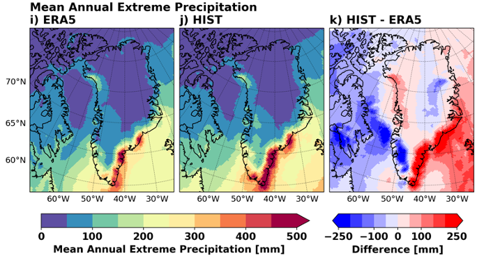
Historical Annual Precipitation Values - ERA5NetCDF
Historical precipitation summary from ERA5. Variables: ann_precip: mean annual precipitation [mm] ex_thres: extreme daily precipitation threshold [mm] ex_precip: mean annual accumulation...
-
Historical Annual Precipitation Values - CESM2.2NetCDF
Historical precipitation summary from CESM2.2. Variables: ann_precip: mean annual precipitation [mm] ex_thres: extreme daily precipitation threshold [mm]
-
Historical Annual Precipitation Values - VR-CESM HISTNetCDF
Historical precipitation summary from VR-CESM HIST. Variables: ann_precip: mean annual precipitation [mm] ex_thres: extreme daily precipitation threshold [mm] ex_precip: mean annual...
-
Annual Cyclone Track DensityNetCDF
Average annual cyclone track densities for ERA5 and VR-CESM simulations. Variables: hist_trkdens: average annual track density in VR-CESM HIST [Tracks per 40,000 km2] fut_trkdens: average...
-
Annual Atmospheric River DaysNetCDF
Average annual number of days each grid cell is impacted by an AR for ERA5 and VR-CESM simulations. Variables: hist_ar_days: average annual number of AR days in VR-CESM HIST [days/year]...
-
Annual Extreme Precipitation Association with Cyclones and Atmospheric RiversNetCDF
Percent of all annual extreme precipitation days in each grid cell occurring with a cyclone and/or an AR present in the same grid cell for ERA5 and VR-CESM simulations. Variables:...
-
Winter (JFM) Cyclone Track DensityNetCDF
Average seasonal cyclone track densities for JFM (winter) for ERA5 and VR-CESM simulations. Variables: hist_trkdens: average seasonal track density in VR-CESM HIST [Tracks per 40,000 km2]...
-
Summer (JAS) Cyclone Track DensityNetCDF
Average seasonal cyclone track densities for JAS (summer) for ERA5 and VR-CESM simulations. Variables: hist_trkdens: average seasonal track density in VR-CESM HIST [Tracks per 40,000 km2]...
-
Winter (JFM) Atmospheric River DaysNetCDF
Average seasonal number of days each grid cell is impacted by an AR for JFM (winter) for ERA5 and VR-CESM simulations. Variables: hist_ar_days: average seasonal number of AR days in VR-...
-
Summer (JAS) Atmospheric River DaysNetCDF
Average seasonal number of days each grid cell is impacted by an AR for JAS (summer) for ERA5 and VR-CESM simulations. Variables: hist_ar_days: average seasonal number of AR days in VR-...
-
Winter (JFM) Extreme Precipitation Association with Cyclones and Atmospheric RiversNetCDF
Percent of all extreme precipitation days in winter (JFM) in each grid cell occurring with a cyclone and/or an AR present in the same grid cell for ERA5 and VR-CESM simulations....
-
Summer (JAS) Extreme Precipitation Association with Cyclones and Atmospheric RiversNetCDF
Percent of all extreme precipitation days in summer (JAS) in each grid cell occurring with a cyclone and/or an AR present in the same grid cell for ERA5 and VR-CESM simulations....
Metadata
| Field | Value |
|---|---|
| Dataset Collection Start Date | 1979-01-01 |
| Dataset Collection End Date | 2100-01-01 |
| Spatial regions | Greenland |
| Spatial extent West Bound Longitude | |
| Spatial extent East Bound Longitude | |
| Spatial extent South Bound Latitude | |
| Spatial extent North Bound Latitude |
| Field | Value |
|---|---|
| Sample Collection | |
| Activity Collection Type | |
| Preferred citation | |
| Analytical Instrument |
|
| Analytical Method |
| Field | Value |
|---|---|
| Licence Name or Copyright Statement | Creative Commons Attribution 4.0 International |
| Licence Type | Open |
| Embargo Date | |
| Licence URL | https://spdx.org/licenses |
| Terms of Access | CanWIN datasets are licensed individually, however most are licensed under the Creative Commons Attribution 4.0 International (CC BY 4.0) Public License. Details for the licence applied can be found using the Licence URL link provided with each dataset. By using data and information provided on this site you accept the terms and conditions of the License. Unless otherwise specified, the license grants the rights to the public to use and share the data and results derived therefrom as long as the proper acknowledgment is given to the data licensor (citation), that any alteration to the data is clearly indicated, and that a link to the original data and the license is made available. |
| Terms of Use | By accessing this data you agree to CanWIN's Terms of Use. |
| Field | Value |
|---|---|
| Dataset Authors |
|
| Contributors |
|
| Project Data Curator | Crawford, Alex |
| Project Data Curator email | alex.crawford@umanitoba.ca |
| Project Data Curator Affiliation | |
| Awards |
| Field | Value |
|---|---|
| Related Resources |
|
| Field | Value |
|---|---|
| Publications |
|