Data and Resources
Data
-
2022152-010-006 Spring data processed.zipZIP
Compressed folder containing full or averaged CTD profile (.csv) of discrete locations on Lake Winnipeg. For each profile generated there is an associated Matlab script detailing the...
-
2022201-010-006 Summer data processed.zipZIP
Compressed folder containing full or averaged CTD profile (.csv) of discrete locations on Lake Winnipeg. For each profile generated there is an associated Matlab script detailing the...
-
2022259-010-006 Fall data processed.zipZIP
Compressed folder containing full or averaged CTD profile (.csv) of discrete locations on Lake Winnipeg. For each profile generated there is an associated Matlab script detailing the...
-
LWRC 2022 Spring Seabird Rosette DATA Mapped.zipZIP
This dataset is composed of images including chlorophyll, dissolved oxygen, specific conductance, surface PAR, temperature, and turbidity measurements on Lake Winnipeg.
-
LWRC 2022 Summer Seabird Rosette DATA Mapped.zipZIP
This dataset is composed of images including chlorophyll, dissolved oxygen, specific conductance, surface PAR, temperature, and turbidity measurements on Lake Winnipeg.
-
LWRC 2022 Fall Seabird Rosette DATA Mapped.zipZIP
This dataset is composed of images including chlorophyll, dissolved oxygen, specific conductance, surface PAR, temperature, and turbidity measurements on Lake Winnipeg.
Supplemental
-
Spring mapped chlorophyllPNG
Image of spring chlorophyll measurements on Lake Winnipeg.
-
Spring mapped dissolved oxygenPNG
Image of spring dissolved oxygen measurements on Lake Winnipeg.
-
Spring mapped specific conductancePNG
Image of spring specific conductance measurements on Lake Winnipeg.
-
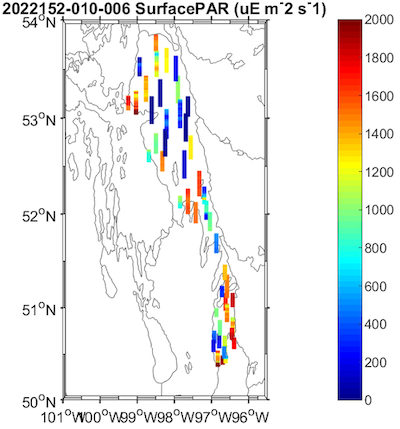
Spring mapped photosynthetically Active Radiation (PAR)PNG
Image of spring surface photosynthetically Active Radiation (PAR) measurements on Lake Winnipeg.
-
Spring mapped temperaturePNG
Image of spring temperature measurements on Lake Winnipeg.
-
Spring mapped turbidityPNG
Image of spring surface turbidity measurements on Lake Winnipeg.
Metadata
| Field | Value |
|---|---|
| Dataset Name | LWRC 2022 Seabird Rosette Data |
| Dataset General Type | Namao CTD data collection |
| Dataset Type | Collection |
| Dataset Level | 1.1-Quality Controlled Data |
| Program Website | https://www.lakewinnipegresearch.org/ |
| Keyword Vocabulary | Polar Data Catalogue |
| Keyword Vocabulary URL | https://www.polardata.ca/pdcinput/public/keywordlibrary |
| Theme |
Freshwater
|
| Dataset Status | Complete |
| Maintenance and Update Frequency | Not planned |
| Dataset Last Revision Date | 2019-12-18 |
| Dataset DOI | |
| Metadata Creation Date | 2024 |
| Publisher | CanWIN |
| Field | Value |
|---|---|
| Dataset Collection Start Date | 2022-06-01 |
| Dataset Collection End Date | 2022-09-28 |
| Spatial regions | Lake Winnipeg |
| Spatial extent West Bound Longitude | |
| Spatial extent East Bound Longitude | |
| Spatial extent South Bound Latitude | |
| Spatial extent North Bound Latitude |
| Field | Value |
|---|---|
| Sample Collection | |
| Activity Collection Type | Field Measurement |
| Preferred citation | |
| Analytical Instrument |
|
| Analytical Method |
| Field | Value |
|---|---|
| Licence Name or Copyright Statement | Open Government Licence 2.0 – Canada |
| Licence Type | Open |
| Embargo Date | |
| Licence URL | https://spdx.org/licenses |
| Terms of Access | CanWIN datasets are licensed individually, however most are licensed under the Creative Commons Attribution 4.0 International (CC BY 4.0) Public License. Details for the licence applied can be found using the Licence URL link provided with each dataset. By using data and information provided on this site you accept the terms and conditions of the License. Unless otherwise specified, the license grants the rights to the public to use and share the data and results derived therefrom as long as the proper acknowledgment is given to the data licensor (citation), that any alteration to the data is clearly indicated, and that a link to the original data and the license is made available. |
| Terms of Use | By accessing this data you agree to CanWIN's Terms of Use. |
| Field | Value |
|---|---|
| Dataset Authors |
|
| Contributors |
|
| Project Data Curator | Smiley, Carley |
| Project Data Curator email | carley.smiley@ec.gc.ca |
| Project Data Curator Affiliation | Environment and Climate Change Canada |
| Awards |
| Field | Value |
|---|---|
| Related Resources |
|
| Field | Value |
|---|---|
| Publications |
|
