{"help": "https://canwin-datahub.ad.umanitoba.ca/data/fr/api/3/action/help_show?name=package_show", "success": true, "result": {"Creator": "Creator", "Date": "2019-12-18", "IdentifierType": "DOI", "PublicationYear": "2026", "Publisher": "CanWIN", "RelatedIdentifierType": "URL", "RelationType": "IsSupplementTo", "ResourceType": "Namao CTD data collection", "Rights": "Open Government Licence 2.0 \u2013 Canada", "Version": "1.0", "accessTerms": "CanWIN datasets are licensed individually, however most are licensed under the Creative Commons Attribution 4.0 International (CC BY 4.0) Public License. Details for the licence applied can be found using the Licence URL link provided with each dataset. \r\nBy using data and information provided on this site you accept the terms and conditions of the License. Unless otherwise specified, the license grants the rights to the public to use and share the data and results derived therefrom as long as the proper acknowledgment is given to the data licensor (citation), that any alteration to the data is clearly indicated, and that a link to the original data and the license is made available.", "activityCollectionType": "Field Measurement", "author": null, "author_email": null, "campaignEndDate": "", "campaignStartDate": "", "contributorName": "Smiley, Carley", "contributorType": "DataCurator", "creator_user_id": "59fdde0d-f226-4e5e-99ba-562b96c239a0", "dataCuratorAffiliation": "Environment and Climate Change Canada", "dataCuratorEmail": "carley.smiley@ec.gc.ca", "datasetCitation": "", "datasetLevel": "1.1", "datasetPublisher": "CanWIN", "dateType": "Updated", "descriptionType": "Abstract", "embargoDate": "", "endDate": "2022-09-28", "endDateType": "Other", "frequency": "Not planned", "id": "76f9b50a-774e-4a06-a9d4-315ee5aacdac", "isopen": false, "kvSchemeURI": "https://www.polardata.ca/pdcinput/public/keywordlibrary", "licenceShemeURI": "https://spdx.org/licenses", "licenceType": "Open", "license_id": null, "license_title": null, "maintainer": null, "maintainer_email": null, "metadata_created": "2024-10-07T20:38:02.025334", "metadata_modified": "2026-04-02T15:04:16.773082", "methodCitation": "", "name": "lwrc-2022-rosette-data", "notes": "Data collected in 2022 during the spring, summer, and fall cruises aboard the M/V NAMAO.\r\nData collected using a shipboard Seabird water quality profiler and four-channel profiling sonde (\u201cSeabird rosette\u201d).\r\nDataset also includes mapped profiles of Seabird parameters measured at respective sampling stations, as well as Matlab scripts that produced each profile (CSVs).\r\n
\r\n\r\n**Check out some results!**\r\n
\r\nThis image shows photosynthetically Active Radiation (PAR) measurements across Lake Winnipeg during spring 2022.\r\n\r\n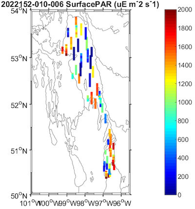\r\n\r\n
\ud83d\udcf8 Quickly view more images under **Supplemental** below, or download all images in the **Mapped** zipped folders. \r\n\r\n", "num_resources": 12, "num_tags": 10, "organization": {"id": "8dd617ee-bcb9-46c1-8d6c-f14394f73c3b", "name": "lwrc", "title": "Lake Winnipeg Research Consortium Inc.", "type": "organization", "description": "The Lake Winnipeg Research Consortium (LWRC) Inc. is a registered charity, founded in 1998 to facilitate scientific research on Lake Winnipeg following evidence of water quality deterioration related to the 1997 Red River \u201cFlood of the Century\u201d. The LWRC was incorporated in Manitoba in 2001 and received charitable status in 2008.\r\n\r\nThe LWRC\u2019s __Science Program__ coordinates whole lake scientific research and monitoring on Lake Winnipeg to gain a better understanding of ecological processes and how they are changing over time, and to support lake and watershed management decision making. \r\n\r\nCurrently, the Science Program offers science support and infrastructure in the form of:\r\n\r\n- Two research vessels, Motor Vessel (M/V) NAMAO and M/V FYLGJA; \r\n\r\n- Since 2002, three whole lake surveys during the open water season (spring, \r\nsummer, fall) each of which includes access to an established network of stations;\r\n\r\n- A network of 65 sampling stations (including offshore, nearshore, river mouths, and outflows);\r\n\r\n- Lake access for Special Projects, upon request; and\r\n\r\n- A Scholarship to honours and graduate students.\r\n\r\nThe LWRC also holds an annual Science Workshop to convene the active science agencies. Annual program reports and State of the Science reports can be found on the Documents page of the LWRC\u2019s website. \r\n\r\n__Board of Directors__: The LWRC is governed by a board of nine directors with representation from the various classes of membership, which includes: Research (3 directors); Contributing (3 directors); Participating (2 directors); and General (1 director).\r\n\r\nThe election of directors from any particular class of membership, if required, takes place during the Annual General Meeting.\r\n\r\n__Personnel__: Three part-time personnel oversee the day to day operations of the LWRC, its programs and research vessels.\r\n\r\n- \uf0a7Dr. Al Kristofferson | Managing Director\r\n\uf0a7\r\n- Dr. Karen Scott | Science & Education Programs\r\n\uf0a7\r\n- Ryan Johnson | Superintendent of Marine Operations & Chief Engineer \r\n\r\n__Crew of the Motor Vessel NAMAO__: The M/V NAMAO requires a seasonal crew of nine: Captain, Chief Officer, Chief Engineer, 2nd Engineer, Deckhands (4) and a Cook. In addition, a seasonal Field Operations Technician oversees sample collection as part of the Science Program.\r\n\r\n__Members__: Current membership of the LWRC is over 30 agencies representing various government and university departments, municipalities, communities, corporate and other organizations. To become a member of the LWRC, please review the \u201cCriteria for Membership\u201d found on the Documents page of the LWRC\u2019s website. The LWRC\u2019s Board of Directors will review your request and a response will follow. There is no fee to become a member.\r\n", "image_url": "https://canwin-datahub.ad.umanitoba.ca/sites/default/files/users/user41/Facility%20photo_KJS_LRm.jpg", "created": "2017-07-21T13:16:45.307875", "is_organization": true, "approval_status": "approved", "state": "active"}, "owner_org": "8dd617ee-bcb9-46c1-8d6c-f14394f73c3b", "private": false, "projectImage": "", "relatedIdentifier": "https://www.lakewinnipegresearch.org/", "related_campaigns": [], "related_deployments": [], "related_instruments": [], "related_platforms": [], "related_programs": ["d8cc6aa0-bf9f-45fe-a266-6fc6c0b624b8"], "related_publications": [], "resourceTypeGeneral": "Collection", "rightsIdentifier": "OGL-Canada-2.0", "rightsIdentifierScheme": "SPDX", "rightsURI": "https://spdx.org/licenses/OGL-Canada-2.0.html", "spatial": "{\"type\":\"Polygon\",\"coordinates\":[[[-97.4678106772,49.9656068566],[-100.0443368343,53.7029355313],[-97.8094847354,54.2623477792],[-95.2329585783,50.5736755077],[-97.4678106772,49.9656068566]]]}", "spatial_regions": "lake-winnipeg", "startDate": "2022-06-01", "startDateType": "Collected", "state": "active", "status": "Complete", "subjectScheme": "Polar Data Catalogue", "theme": ["8f8cd877-b037-4b1a-b928-f86d9e093741", "7e6d0f18-a602-4564-9c75-184b848774a4", "520a54ad-aa0f-437b-9e84-8cb140bad3b8", "c9619331-6f8d-434f-b240-9a5d2de03893", "f9c7bfc1-c11e-4bc1-8b44-847d078bf529"], "title": "LWRC 2022 Seabird Rosette Data", "titleType": "Alternative Title", "type": "dataset", "url": null, "useTerms": "By accessing this data you agree to [CanWIN's Terms of Use](/data/publication/canwin-data-statement/resource/5b942a87-ef4e-466e-8319-f588844e89c0).", "version": null, "analyticalInstrument": [{"Title": "", "analyticalInstrumentIdentifier": "", "identifierType": "", "name": "Seabird Rosette", "titleType": "Alternative Title"}], "analyticalMethod": [{"analyticalMethodName": "", "comments": "", "laboratory": "", "methodLink": "", "methodSummary": "", "variablesMeasured": ""}], "awards": [{"awardTitle": "", "awardURI": "", "funderIdentifierType": "", "funderName": "", "funderSchemeURI": ""}], "contributors": [{"affiliation": "Lake Winnipeg Research Consortium", "contributorName": "Scott, Karen", "contributorType": "ProjectManager", "email": "kjs@lakewinnipegresearch.org", "nameIdentifier": ""}], "creatorName": [{"author": "Yerubandi, Ram", "creatorAffiliation": "Environment and Climate Change Canada", "creatorEmail": "ram.yerubandi@canada.ca", "creatorNameIdentifier": "", "nameType": "Personal"}], "groups": [{"description": "Fraction of absorbed photosynthetically active radiation (FAPAR) data describe the proportion of incoming sunlight in the photosynthetically active range that is absorbed by vegetation canopies. These data products support monitoring of plant productivity, vegetation health, crop and ecosystem modelling, carbon cycle studies, and assessment of seasonal and long-term changes in terrestrial ecosystems.", "display_name": "Fraction of Absorbed Photosynthetically Active Radiation (FAPAR)", "id": "c9619331-6f8d-434f-b240-9a5d2de03893", "image_display_url": "https://canwin-datahub.ad.umanitoba.ca/data/uploads/group/2026-02-11-174025.093644Fraction-of-Absorbed-Photosynthetically-Active-Radiation-FAPAR.svg", "name": "fraction-of-absorbed-photosynthetically-active-radiation-fapar", "title": "Fraction of Absorbed Photosynthetically Active Radiation (FAPAR)"}, {"description": "Inland water features, drainage systems and their characteristics. Examples of data you can find here include river and lake data, water quality data. \r\n\r\nIn CEOS, related research themes include biogeochemistry, Inland lakes and waters, modelling, remote sensing and technology, trace metals and contaminants.", "display_name": "Freshwater", "id": "8f8cd877-b037-4b1a-b928-f86d9e093741", "image_display_url": "https://canwin-datahub.ad.umanitoba.ca/data/uploads/group/2021-10-31-211937.658599hyinspirehydrography.svg", "name": "freshwater", "title": "Freshwater"}, {"description": "Oxygen data products describe the concentration and distribution of dissolved oxygen in marine and freshwater environments. These data products support monitoring of ecosystem health, hypoxia and \u201cdead zone\u201d detection, water quality assessment, fisheries and habitat studies, and analysis of long-term changes in ocean and lake oxygen levels linked to climate and nutrient inputs.", "display_name": "Oxygen", "id": "520a54ad-aa0f-437b-9e84-8cb140bad3b8", "image_display_url": "https://canwin-datahub.ad.umanitoba.ca/data/uploads/group/2026-02-11-190744.868936Water-Colour.svg", "name": "oxygen", "title": "Oxygen"}, {"description": "Subsurface salinity data products describe the concentration of dissolved salts in seawater below the surface, across different depths and water masses. These data products support studies of ocean circulation, mixing processes, water mass formation, climate variability, and long-term changes in ocean structure and freshwater input.", "display_name": "Subsurface Salinity", "id": "f9c7bfc1-c11e-4bc1-8b44-847d078bf529", "image_display_url": "https://canwin-datahub.ad.umanitoba.ca/data/uploads/group/2026-02-11-185407.731334Subsurface-Salinity.svg", "name": "subsurface-salinity", "title": "Subsurface Salinity"}, {"description": "Subsurface temperature data products describe the temperature of seawater below the surface across different depths and ocean layers. These data products support monitoring of ocean heat content, climate and circulation studies, marine ecosystem research, and analysis of long-term changes in ocean structure and heat transport.", "display_name": "Subsurface Temperature", "id": "7e6d0f18-a602-4564-9c75-184b848774a4", "image_display_url": "https://canwin-datahub.ad.umanitoba.ca/data/uploads/group/2026-02-11-185516.127976Subsurface-Temperature.svg", "name": "subsurface-temperature", "title": "Subsurface Temperature"}], "publications": [{"RelatedIdentifier": "", "ResourceTypeGeneral": "", "name": "DePalma, S., 2010. Quality assurance procedures for shipboard depth- dependent profiled data. Document RS-10-002, Environment Canada, Canada Centre for Inland Waters, Burlington, ON", "relatedIdentifierType": "", "relationType": "", "resourceType": "Online Resource"}], "resources": [{"cache_last_updated": null, "cache_url": null, "created": "2024-10-07T20:50:12.631393", "datastore_active": false, "datastore_contains_all_records_of_source_file": false, "description": "Compressed folder containing full or averaged CTD profile (.csv) of discrete locations on Lake Winnipeg. For each profile generated there is an associated Matlab script detailing the processing code of the profile.", "format": "ZIP", "hash": "", "id": "149fa4d2-b948-4de7-8728-5d94501b0a9f", "last_modified": "2024-10-07T20:50:12.534076", "metadata_modified": "2024-10-07T20:50:31.500583", "mimetype": "application/zip", "mimetype_inner": null, "name": "2022152-010-006 Spring data processed.zip", "package_id": "76f9b50a-774e-4a06-a9d4-315ee5aacdac", "position": 0, "resCategory": "data", "resource_type": null, "size": 1462490, "state": "active", "url": "https://canwin-datahub.ad.umanitoba.ca/data/dataset/76f9b50a-774e-4a06-a9d4-315ee5aacdac/resource/149fa4d2-b948-4de7-8728-5d94501b0a9f/download/2022152-010-006_spring.zip", "url_type": "upload"}, {"cache_last_updated": null, "cache_url": null, "created": "2024-10-07T20:50:31.518704", "datastore_active": false, "datastore_contains_all_records_of_source_file": false, "description": "Compressed folder containing full or averaged CTD profile (.csv) of discrete locations on Lake Winnipeg. For each profile generated there is an associated Matlab script detailing the processing code of the profile.", "format": "ZIP", "hash": "", "id": "374b7da6-061a-4fdc-80f1-563d0c872961", "last_modified": "2024-10-07T20:50:31.412357", "metadata_modified": "2024-10-07T20:51:28.895354", "mimetype": "application/zip", "mimetype_inner": null, "name": "2022201-010-006 Summer data processed.zip", "package_id": "76f9b50a-774e-4a06-a9d4-315ee5aacdac", "position": 1, "resCategory": "data", "resource_type": null, "size": 908226, "state": "active", "url": "https://canwin-datahub.ad.umanitoba.ca/data/dataset/76f9b50a-774e-4a06-a9d4-315ee5aacdac/resource/374b7da6-061a-4fdc-80f1-563d0c872961/download/2022201-010-006_summer.zip", "url_type": "upload"}, {"cache_last_updated": null, "cache_url": null, "created": "2024-10-07T20:50:46.430647", "datastore_active": false, "datastore_contains_all_records_of_source_file": false, "description": "Compressed folder containing full or averaged CTD profile (.csv) of discrete locations on Lake Winnipeg. For each profile generated there is an associated Matlab script detailing the processing code of the profile.", "format": "ZIP", "hash": "", "id": "54d7c1d0-3cfa-4925-8abe-ef9e468899be", "last_modified": "2024-10-07T20:50:46.312271", "metadata_modified": "2024-10-07T20:54:08.860670", "mimetype": "application/zip", "mimetype_inner": null, "name": "2022259-010-006 Fall data processed.zip", "package_id": "76f9b50a-774e-4a06-a9d4-315ee5aacdac", "position": 2, "resCategory": "data", "resource_type": null, "size": 938446, "state": "active", "url": "https://canwin-datahub.ad.umanitoba.ca/data/dataset/76f9b50a-774e-4a06-a9d4-315ee5aacdac/resource/54d7c1d0-3cfa-4925-8abe-ef9e468899be/download/2022259-010-006_fall.zip", "url_type": "upload"}, {"cache_last_updated": null, "cache_url": null, "created": "2024-10-07T20:54:08.885492", "datastore_active": false, "datastore_contains_all_records_of_source_file": false, "description": "This dataset is composed of images including chlorophyll, dissolved oxygen, specific conductance, surface PAR, temperature, and turbidity measurements on Lake Winnipeg.", "format": "ZIP", "hash": "", "id": "907beaf2-3859-482a-8a9c-a193f72cb65f", "last_modified": "2024-10-07T20:54:08.765767", "metadata_modified": "2024-10-07T20:54:25.864590", "mimetype": "application/zip", "mimetype_inner": null, "name": "LWRC 2022 Spring Seabird Rosette DATA Mapped.zip", "package_id": "76f9b50a-774e-4a06-a9d4-315ee5aacdac", "position": 3, "resCategory": "data", "resource_type": null, "size": 368396, "state": "active", "url": "https://canwin-datahub.ad.umanitoba.ca/data/dataset/76f9b50a-774e-4a06-a9d4-315ee5aacdac/resource/907beaf2-3859-482a-8a9c-a193f72cb65f/download/lwrc-2022-spring-seabird-rosette-data-mapped.zip", "url_type": "upload"}, {"cache_last_updated": null, "cache_url": null, "created": "2024-10-07T20:54:25.886634", "datastore_active": false, "datastore_contains_all_records_of_source_file": false, "description": "This dataset is composed of images including chlorophyll, dissolved oxygen, specific conductance, surface PAR, temperature, and turbidity measurements on Lake Winnipeg.", "format": "ZIP", "hash": "", "id": "878579b4-2bed-4eb4-9e8d-ea4f40d91855", "last_modified": "2024-10-07T20:54:25.764982", "metadata_modified": "2024-10-07T20:55:19.656372", "mimetype": "application/zip", "mimetype_inner": null, "name": "LWRC 2022 Summer Seabird Rosette DATA Mapped.zip", "package_id": "76f9b50a-774e-4a06-a9d4-315ee5aacdac", "position": 4, "resCategory": "data", "resource_type": null, "size": 369985, "state": "active", "url": "https://canwin-datahub.ad.umanitoba.ca/data/dataset/76f9b50a-774e-4a06-a9d4-315ee5aacdac/resource/878579b4-2bed-4eb4-9e8d-ea4f40d91855/download/lwrc-2022-summer-seabird-rosette-data-mapped.zip", "url_type": "upload"}, {"cache_last_updated": null, "cache_url": null, "created": "2024-10-07T20:55:19.674033", "datastore_active": false, "datastore_contains_all_records_of_source_file": false, "description": "This dataset is composed of images including chlorophyll, dissolved oxygen, specific conductance, surface PAR, temperature, and turbidity measurements on Lake Winnipeg.", "format": "ZIP", "hash": "", "id": "5186b135-ba15-45eb-88b2-824403657f37", "last_modified": "2024-10-07T20:55:19.559199", "metadata_modified": "2024-10-07T20:57:10.339382", "mimetype": "application/zip", "mimetype_inner": null, "name": "LWRC 2022 Fall Seabird Rosette DATA Mapped.zip", "package_id": "76f9b50a-774e-4a06-a9d4-315ee5aacdac", "position": 5, "resCategory": "data", "resource_type": null, "size": 373605, "state": "active", "url": "https://canwin-datahub.ad.umanitoba.ca/data/dataset/76f9b50a-774e-4a06-a9d4-315ee5aacdac/resource/5186b135-ba15-45eb-88b2-824403657f37/download/lwrc-2022-fall-seabird-rosette-data-mapped.zip", "url_type": "upload"}, {"cache_last_updated": null, "cache_url": null, "created": "2024-10-07T20:57:10.364586", "datastore_active": false, "datastore_contains_all_records_of_source_file": false, "description": "Image of spring chlorophyll measurements on Lake Winnipeg.\r\n\r\n", "format": "PNG", "hash": "", "id": "223f27d9-4913-4998-ae39-0ebf1ee7af42", "last_modified": "2024-10-07T20:57:10.221792", "metadata_modified": "2024-10-07T21:01:18.099328", "mimetype": "image/png", "mimetype_inner": null, "name": "Spring mapped chlorophyll", "package_id": "76f9b50a-774e-4a06-a9d4-315ee5aacdac", "position": 6, "resCategory": "supplemental", "resource_type": null, "size": 63347, "state": "active", "url": "https://canwin-datahub.ad.umanitoba.ca/data/dataset/76f9b50a-774e-4a06-a9d4-315ee5aacdac/resource/223f27d9-4913-4998-ae39-0ebf1ee7af42/download/2022152-010-006chlorophyll.png", "url_type": "upload"}, {"cache_last_updated": null, "cache_url": null, "created": "2024-10-07T20:57:47.757944", "datastore_active": false, "datastore_contains_all_records_of_source_file": false, "description": "Image of spring dissolved oxygen measurements on Lake Winnipeg.\r\n\r\n", "format": "PNG", "hash": "", "id": "18877370-939f-413b-808c-8fd1a69ad10c", "last_modified": "2024-10-07T20:57:47.618393", "metadata_modified": "2024-10-07T21:01:41.704419", "mimetype": "image/png", "mimetype_inner": null, "name": "Spring mapped dissolved oxygen", "package_id": "76f9b50a-774e-4a06-a9d4-315ee5aacdac", "position": 7, "resCategory": "supplemental", "resource_type": null, "size": 65394, "state": "active", "url": "https://canwin-datahub.ad.umanitoba.ca/data/dataset/76f9b50a-774e-4a06-a9d4-315ee5aacdac/resource/18877370-939f-413b-808c-8fd1a69ad10c/download/2022152-010-006dissolvedoxygen.png", "url_type": "upload"}, {"cache_last_updated": null, "cache_url": null, "created": "2024-10-07T20:58:17.755523", "datastore_active": false, "datastore_contains_all_records_of_source_file": false, "description": "Image of spring specific conductance measurements on Lake Winnipeg.", "format": "PNG", "hash": "", "id": "84cecca6-666c-426e-9f01-82fe920ca6a2", "last_modified": "2024-10-07T20:58:17.619870", "metadata_modified": "2024-10-07T21:02:04.676675", "mimetype": "image/png", "mimetype_inner": null, "name": "Spring mapped specific conductance", "package_id": "76f9b50a-774e-4a06-a9d4-315ee5aacdac", "position": 8, "resCategory": "supplemental", "resource_type": null, "size": 62579, "state": "active", "url": "https://canwin-datahub.ad.umanitoba.ca/data/dataset/76f9b50a-774e-4a06-a9d4-315ee5aacdac/resource/84cecca6-666c-426e-9f01-82fe920ca6a2/download/2022152-010-006specificconductance.png", "url_type": "upload"}, {"cache_last_updated": null, "cache_url": null, "created": "2024-10-07T20:58:42.107122", "datastore_active": false, "datastore_contains_all_records_of_source_file": false, "description": "Image of spring surface photosynthetically Active Radiation (PAR) measurements on Lake Winnipeg.", "format": "PNG", "hash": "", "id": "e22bb8b1-43d6-4883-a229-552f47d61a0f", "last_modified": "2024-10-07T20:58:41.801324", "metadata_modified": "2024-10-07T21:02:27.841735", "mimetype": "image/png", "mimetype_inner": null, "name": "Spring mapped photosynthetically Active Radiation (PAR)", "package_id": "76f9b50a-774e-4a06-a9d4-315ee5aacdac", "position": 9, "resCategory": "supplemental", "resource_type": null, "size": 60970, "state": "active", "url": "https://canwin-datahub.ad.umanitoba.ca/data/dataset/76f9b50a-774e-4a06-a9d4-315ee5aacdac/resource/e22bb8b1-43d6-4883-a229-552f47d61a0f/download/2022152-010-006surfacepar.png", "url_type": "upload"}, {"cache_last_updated": null, "cache_url": null, "created": "2024-10-07T20:59:12.512208", "datastore_active": false, "datastore_contains_all_records_of_source_file": false, "description": "Image of spring temperature measurements on Lake Winnipeg.", "format": "PNG", "hash": "", "id": "ec20113b-4204-449e-a69a-ebc8c044f76a", "last_modified": "2024-10-07T20:59:12.371415", "metadata_modified": "2024-10-07T21:00:54.883683", "mimetype": "image/png", "mimetype_inner": null, "name": "Spring mapped temperature", "package_id": "76f9b50a-774e-4a06-a9d4-315ee5aacdac", "position": 10, "resCategory": "supplemental", "resource_type": null, "size": 61014, "state": "active", "url": "https://canwin-datahub.ad.umanitoba.ca/data/dataset/76f9b50a-774e-4a06-a9d4-315ee5aacdac/resource/ec20113b-4204-449e-a69a-ebc8c044f76a/download/2022152-010-006temperature.png", "url_type": "upload"}, {"cache_last_updated": null, "cache_url": null, "created": "2024-10-07T20:59:42.379151", "datastore_active": false, "datastore_contains_all_records_of_source_file": false, "description": "Image of spring surface turbidity measurements on Lake Winnipeg.", "format": "PNG", "hash": "", "id": "19516aba-6e5a-4252-87ab-3bb132c8ce4e", "last_modified": "2024-10-07T20:59:42.231761", "metadata_modified": "2026-02-24T00:03:53.763280", "mimetype": "image/png", "mimetype_inner": null, "name": "Spring mapped turbidity", "package_id": "76f9b50a-774e-4a06-a9d4-315ee5aacdac", "position": 11, "resCategory": "supplemental", "resource_type": null, "size": 62739, "state": "active", "url": "https://canwin-datahub.ad.umanitoba.ca/data/dataset/76f9b50a-774e-4a06-a9d4-315ee5aacdac/resource/19516aba-6e5a-4252-87ab-3bb132c8ce4e/download/2022152-010-006turbidity.png", "url_type": "upload"}], "sample_collection": [{"comment": "", "instrumentTitle": "Seabird Rosette", "methodDescrioption": "", "methodDescriptionType": "Methods", "methodTitle": "", "methodUrl": "", "standardized_instrument_name": "Seabird CTD"}], "supplementalResources": [{"RelatedIdentifier": "", "ResourceTypeGeneral": "", "name": "", "relatedIdentifierType": "", "relationship": "", "resourceType": "Online Resource", "seriesName": ""}], "tags": [{"display_name": "CTD profiles", "id": "64cfeaaa-97b1-47c2-9b9c-8668f75476c5", "name": "CTD profiles", "state": "active", "vocabulary_id": null}, {"display_name": "Conductivity", "id": "d3abab83-b3ba-4fbb-9c5f-8f83cf86d748", "name": "Conductivity", "state": "active", "vocabulary_id": null}, {"display_name": "Depth", "id": "368f3921-0ca2-4cb5-82f6-5af6c6cd7eb7", "name": "Depth", "state": "active", "vocabulary_id": null}, {"display_name": "Dissolved Oxygen", "id": "0c548446-ff6b-4201-8748-8d26da54424c", "name": "Dissolved Oxygen", "state": "active", "vocabulary_id": null}, {"display_name": "Images", "id": "7af71725-2bcc-4185-89bc-8b602abf6c03", "name": "Images", "state": "active", "vocabulary_id": null}, {"display_name": "Maps", "id": "a3354870-ad48-4725-a89a-f74cfa6b5098", "name": "Maps", "state": "active", "vocabulary_id": null}, {"display_name": "Photosynthetically active radiation", "id": "4df065fc-b8d9-48aa-a362-eddbb9954678", "name": "Photosynthetically active radiation", "state": "active", "vocabulary_id": null}, {"display_name": "Temperature", "id": "ced65b4f-964a-404f-abd4-e0bb58e79798", "name": "Temperature", "state": "active", "vocabulary_id": null}, {"display_name": "Turbidity", "id": "28f03386-65a5-4ca9-81ae-a8b4f9c26a60", "name": "Turbidity", "state": "active", "vocabulary_id": null}, {"display_name": "chlorophyll", "id": "7378338f-fd5a-402f-9758-37d6a08e2130", "name": "chlorophyll", "state": "active", "vocabulary_id": null}], "relationships_as_subject": [], "relationships_as_object": []}}